
Cycling in Sainte-Marie-de-Campan
1 cycling route from Sainte-Marie-de-Campan, France, 17 km, 17 km mapped in all, with up to 1,256 m of climbing in a day. Mountainous riding (74 m of climbing per km on average), mostly road routes. 1 named climb; the high point is 2,110 m on Col du Tourmalet from Sainte-Marie-de-Campan. Best months to ride: Jun to Oct.
At a glance
- Routes
- 1
- Lengths
- 17 km
- Biggest day
- 1,256 m
- Terrain
- Mountainous
- Bike
- Road bike
- Difficulty
- Moderate
- Named climbs
- 1
- Best months
- Jun to Oct
- GPX
- Every route
Know before you go
Added up from the recorded routes and OpenStreetMap; nothing estimated.
- High point
- 2,110 m on Col du Tourmalet from Sainte-Marie-de-Campan.
- Climbs
- 1 named climb · 1 ascent of 500 m or more.
Cycling guide to Sainte-Marie-de-Campan
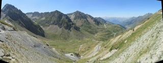
Sainte-Marie-de-Campan offers a notable cycling route up to the Col du Tourmalet. This 17.4 km point-to-point climb features a consistent ascent of 1256 m and reaches a high point of 2110 m. Along the way, cyclists pass through Gripp and La Mongie. The road is fully paved, making it suitable for standard road bikes. The route lies entirely within France and involves 14.1 km on main roads without a cycle lane. The longest stretch without nearby services is 6.9 km, so riders should plan accordingly.
This destination mainly features one significant climb, starting right from Sainte-Marie-de-Campan at 0 km and extending for 17.3 km with gradients averaging 7.2% and reaching a maximum of 14%. The road climbs steadily to the summit at 2110 m, making it a challenging route for cyclists who want to tackle a classic mountain ascent. No railway stations are near the route, and the surface is fully paved throughout.
More on terrain
Terrain
The terrain is mountainous with a single long climb beginning at 0 km, rising 1256 m over 17.3 km to 2110 m elevation. Average gradient is 7.2%, with sections up to 14%.