
Cycling in Gletsch
1 cycling route from Gletsch, Switzerland, 11 km, 11 km mapped in all, with up to 666 m of climbing in a day. Mountainous riding (61 m of climbing per km on average), mostly road routes. 1 named climb; the high point is 2,429 m on Furka Pass from Gletsch. Best months to ride: Jul to Aug.
At a glance
- Routes
- 1
- Lengths
- 11 km
- Biggest day
- 666 m
- Terrain
- Mountainous
- Bike
- Road bike
- Difficulty
- Easy
- Named climbs
- 1
- Best months
- Jul to Aug
- GPX
- Every route
Know before you go
Added up from the recorded routes and OpenStreetMap; nothing estimated.
- High point
- 2,429 m on Furka Pass from Gletsch.
- Climbs
- 1 named climb · 1 ascent of 500 m or more.
Cycling guide to Gletsch
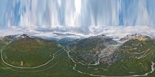
Gletsch in Switzerland is the start of a challenging route up the Furka Pass. This 10.5 km point-to-point climb gains 666 m in altitude on paved roads. Cyclists ride from Gletsch beneath high mountain terrain reaching 2429 m at the pass summit. The route features no gravel, with the entire distance on main roads without cycle lanes. Along the route, three railway stations are nearby, but services remain scarce for long stretches, with the longest gap without amenities measuring 7.6 km. The climb starts almost immediately from the town and lasts the full length of the route. With its direct ascent and high elevation, the Furka Pass from Gletsch provides a focused climbing challenge under mountain peaks. Nearby places are limited as the key destination here is the mountain pass itself.
More on terrain
Terrain
The route is mountainous, climbing 666 m over 10.4 km at an average gradient of 6.4%, reaching a top height of 2429 m. Maximum gradients reach 10.4%, making the terrain a steady and steep ascent on paved roads.