
Cycling in Innertkirchen
2 cycling routes from Innertkirchen, Switzerland, 27 to 28 km, 55 km mapped in all, with up to 1,629 m of climbing in a day. Mountainous riding (58 m of climbing per km on average), mostly road routes. 2 named climbs; the high point is 2,259 m on Susten Pass from Innertkirchen. Best months to ride: May to Oct.
At a glance
- Routes
- 2
- Lengths
- 27–28 km
- Biggest day
- 1,629 m
- Terrain
- Mountainous
- Bike
- Road bike
- Difficulty
- Hard
- Named climbs
- 2
- Best months
- May to Oct
- GPX
- Every route
Know before you go
Added up from the recorded routes and OpenStreetMap; nothing estimated.
- High point
- 2,259 m on Susten Pass from Innertkirchen.
- Climbs
- 2 named climbs · 2 ascents of 500 m or more.
Cycling guide to Innertkirchen
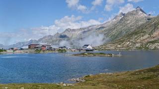
Cyclists starting from Innertkirchen can choose between two main mountain routes: the Grimsel Pass and the Susten Pass. Both routes feature point-to-point rides with distances around 27 km and elevation gains exceeding 1500 m. The Grimsel Pass route passes through Boden and Guttannen, reaching a top elevation of 2163 m. The Susten Pass route heads through Wyler, Hopflauenen, Nessental, Fuhren, Gadmen, and Obermad, peaking at 2259 m. These climbs offer average gradients of about 5.7-5.9%, with maximum gradients over 10%, suitable for riders looking for steep and sustained ascents. The routes are mainly paved with minimal unpaved sections, and multiple railway stations near the routes provide transport options.
More on terrain
Terrain
Both routes feature mountainous terrain with long sustained climbs. Gradients average around 5.7-5.9% with maximum gradients reaching up to 12.3%. The highest point reached is 2259 m. The routes are predominantly on paved main roads without cycle lanes.