
Cycling in Kirkintilloch
1 cycling route from Kirkintilloch, East Dunbartonshire, United Kingdom, 13 km, 13 km mapped in all, with up to 56 m of climbing in a day. Mostly flat riding (4 m of climbing per km on average), mostly road routes, 12 km on cycle paths or lanes. Best months to ride: Jun to Aug.
At a glance
- Routes
- 1
- Lengths
- 13 km
- Biggest day
- 56 m
- Terrain
- Flat
- Surface
- Mostly paved
- Bike
- Road bike
- Difficulty
- Easy
- Best months
- Jun to Aug
- GPX
- Every route
Know before you go
Added up from the recorded routes and OpenStreetMap; nothing estimated.
- Surface
- Paved almost throughout.
- Roads
- 12 km on cycle paths or lanes.
- Bail-outs
- A railway station or ferry within reach on 1 route.
Cycling guide to Kirkintilloch
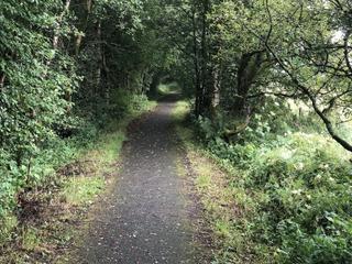
Kirkintilloch in East Dunbartonshire serves as the start of National Cycle Route 755, which extends 12.8 km through Barleybank, Milton of Campsie, Lennoxtown, Ballagan Farm, and ends near Strathblane. The route stays mostly on cycle paths for 12.3 km and includes a railway station near the route for easy access. The ride features very little traffic on main roads without cycle lanes, as none of the 12.8 km is on main roads lacking cycle lanes. Services such as cafés or shops are absent for the longest 6.7 km stretch, so riders should plan accordingly.
More on terrain
Terrain
The terrain is mostly flat to gently rolling with an elevation gain of 56 m over the 12.8 km route. The highest point reaches 93 m, and the cycle path quality is high on mostly paved surfaces with only 2% gravel or unpaved sections.