
Cycling in Larrau
2 cycling routes from Larrau, France, 12 km, 24 km mapped in all, with up to 928 m of climbing in a day. Mountainous riding (73 m of climbing per km on average), mostly road routes. 2 named climbs; the high point is 1,566 m on Port de Larrau from Larrau. Best months to ride: May to Oct.
At a glance
- Routes
- 2
- Lengths
- 12 km
- Biggest day
- 928 m
- Terrain
- Mountainous
- Bike
- Road bike
- Difficulty
- Moderate
- Named climbs
- 2
- Best months
- May to Oct
- GPX
- Every route

Know before you go
Added up from the recorded routes and OpenStreetMap; nothing estimated.
- High point
- 1,566 m on Port de Larrau from Larrau.
- Climbs
- 2 named climbs · 2 ascents of 500 m or more.
Cycling guide to Larrau
Cyclists riding from Larrau in France have challenging climbs to choose from, including routes up to Port de Larrau and Col Bagargui. These point-to-point climbs start near the village and ascend to high points of 1326 m and 1566 m respectively. The climbs have average gradients of 7.8% to 8.7%, with maximum gradients reaching 15% on Port de Larrau and nearly 14% on Col Bagargui. The climbs cover nearly 10 to 12 km with elevation gains between 819 m and 928 m, offering sustained sustained uphill riding.
Both routes are nearly entirely paved with only about 1% unpaved sections. Main roads are used almost throughout but without cycle lanes, and there are no services available for over 11 km on the routes. No railway stations are near these climbs, making Larrau a start point primarily for serious climbing rides rather than convenience stops or shorter outings.
More on terrain
Terrain
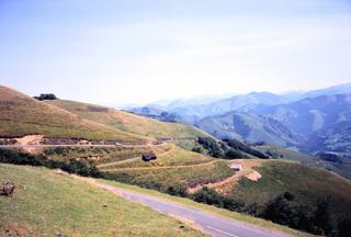
The terrain around Larrau is mountainous, featuring long climbs of 9.5 to 11.8 km with sustained gradients averaging between 7.8% and 8.7%. Maximum gradients are steep, reaching up to 15%, and high points top out at 1566 m.