Road · United Arab Emirates
Down the Stick from Arabian Ranches
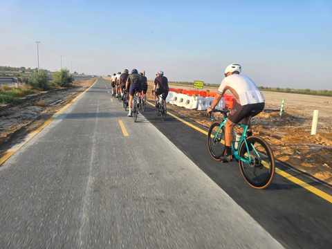
A flat 77 km road cycling loop from Dubai through Wadi Al Safa 7, Al Yalayis 3 and Madinat Hind 4, with 120 m of climbing. 75% is on cycle paths or roads with a cycle lane.
At a glance
- Best for
- Steady riding away from traffic
- Distance
- 76.5 km
- Elevation gain
- 120 m
- Riding time
- 2½–4 hours
- Difficulty
- Moderate
- Bike
- Road bike
- Surface
- Paved
- Traffic
- Mostly cycle paths
- Food & water
- Longest gap 20 km
- Best months
- Dec to Feb
- Navigation
- GPX download
- Start and finish
- Dubai
Map and elevation profile
Elevation profile
- 120 m
- 77 km
What it was like to ride
Route description
- Dubai
- Wadi Al Safa 7
- Al Yalayis 3
- Madinat Hind 4
- Dubai
This 76.5 km loop starts and finishes in Dubai, passing through Wadi Al Safa 7 at 8.2 km, Al Yalayis 3 at 46.2 km, and Madinat Hind 4 at 54.4 km. The route is predominantly flat, with only 2 km combined over 5% gradient including a brief steep section of 2.4% at the start. Elevation varies from 24 m near the finish to a high point of 88 m around 31.7 km.
The surface is fully paved, with 76% of the route on cycle paths, 21% on minor roads, and small sections on a motorway and quiet streets. About 1.4 km is on main roads without dedicated cycle lanes. The longest named section is the Al Qudra Cycle Path Route 4, ridden for 33.2 km. There are shops, cafés, and restaurants accessible off-route with the longest dry stretch between 31.8 km and 51.5 km where there is no café, shop, or water for 19.7 km.
Support facilities include supermarkets at 8.2 km and 63.2 km, convenience stores at 16 km, 31.7 km, and 51.5 km, drinking water and toilets close to 31.8 km, two petrol stations near 31.8 km and 51.5 km, bike rental at 31.8 km, and a bailout ferry station at 75.2 km. The route is best ridden in January when temperatures average 21°C.
Why ride this route?
- 75% on cycle paths or lanes.
Highlights
- Loop route around Dubai
- High point at 88 m at 31.7 km
- Al Qudra Cycle Path Route 4 for 33.2 km
- Longest dry stretch without facilities 19.7 km
Along the route
Places passed
Traffic, surface and gradient
Much of the route is separated from traffic: 75% is on cycle paths or roads with a cycle lane.
- Roads
- 76% cycle path · 21% minor road · 1% motorway · 1% quiet street · 1% other roads and tracks
- Main roads
- 1.4 km on main roads without a cycle lane — likely busier
- Cycle paths
- 57.4 km on cycle paths or roads with a cycle lane
- Main roads used
- Al Qudra Cycle Path Route 4 (33 km)
- Surface
- Paved: 100% of the route is mapped as paved.
- Gradient
- 1% climbing · 1% descending · 98% flat
Food, water and services
The longest stretch without a café, shop or water is 20 km, from km 32 to 52. Along the route: 2 cafés and restaurants, 9 shops, 1 water point, 3 petrol stations, 1 public toilet and 2 bike shops.
Food, water and shops in ride order
- 8.2 kmWest Zone Supermarket · supermarket · 330 m off route
- 8.7 kmFood To Go · café · 380 m off route
- 16 kmZoom · convenience store · 40 m off route
- 16 kmEnoc · petrol station · 50 m off route
- 31.7 kmSpicy Village Restaurant · restaurant · 130 m off route
- 31.7 kmZad Foodstores · convenience store · on the route
- 31.7 kmAlqudra Ambulance Medical Centre · clinic · 120 m off route
- 31.8 kmDrinking water · on the route
- 31.8 kmToilets · on the route
- 31.8 kmTrek · bike rental · 40 m off route
- 31.8 kmADNOC · petrol station · 90 m off route
- 51.5 kmConvenience store · 70 m off route
- 51.5 kmADNOC · petrol station · 90 m off route
- 63.2 kmSpinneys · supermarket · 250 m off route
Need to bail out?
- 75.2 km — Abra Station (ferry), 1.1 km off route
Know before you go
- Longest stretch without café, shop or water: 19.7 km from 31.8 km to 51.5 km
- 1.4 km on main roads without cycle lanes
- 1 km on motorway