Cyclists.com

Col de Néronne from Salers

Salers, FranceRoad

Routed from the map This classic road was traced on OpenStreetMap and measured against the terrain model; no member has recorded it yet. Ridden it? Add your recording and photos.

9 km
Distance
298 m
Elevation gain
Easy
Difficulty
Paved
Surface

Elevation profile

Total ascent
298 m
Distance
9 km
Elevation (m)02505007501,0001,2501,5000 km2 km4 km6 km8 km9 kmHighest point1,242 m at 9.1 kmStart0 kmFinish9 km

Route overview

Suitable for riders looking for a short, moderate climb with gentle gradients.

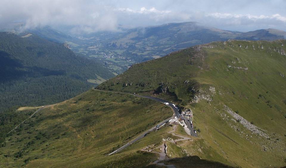
A 9.1 km climb from Salers to Col de Néronne in France with 298 m of elevation gain.

Starting near Salers at 943 m, this ride climbs steadily for 8.7 km up the D 680 main road to the Col de Néronne at 1242 m. The average gradient is 3.4%, reaching a maximum of 5.3% over 0.8 km, making for a gentle but consistent ascent. The initial 4.5 km section carries 69% of the total elevation gain, with the gradient easing slightly towards the top. The entire route is paved and primarily on a main road, 8.9 km of which lack a cycle lane and 3.8 km have speed limits of 80 km/h or higher. There is a longest stretch without a café, shop, or water of 3.8 km from 4.5 km to 8.3 km. Starting near Salers, there are several eating places and refuelling options at the beginning and at 4.5 km. Water is also available near the start and at 8.3 km.

Highlights

  • Col de Néronne summit at 1242 m
  • D 680 main road climbing 8.7 km
  • Several eateries near Salers start
  • Longest supply gap 3.8 km between km 4.5 and 8.3

Along the route

Measured from the recorded track and OpenStreetMap.

Climbs

ClimbStarts atLengthGainAverageMaxTop
Salers climb0.3 km8.7 km296 m3.4 %5.3 %1242 m

High point 1242 m at 9.1 km; low point 943 m.

Salers climb · starts at 0.3 km

8.7 km at 3.4% · 296 m
95010001050110011501200ELEVATION (M)3.3%4.5%5.0%3.1%3.0%2.9%2.2%2.1%0 km123456788.7 kmDISTANCE (KM)Salers climb · 1,241 mSTEEPEST 5.0%
< 4%4 – 7%7 – 10%> 10%

What this ride is like

Measured from OpenStreetMap along the track and the elevation profile.

Roads
98% main road
Main roads
8.9 km on main roads without a cycle lane — likely busier
Fast roads
3.8 km on roads with a limit of 80 km/h or more
Main roads used
D 680 (9 km)
Surface
Paved throughout
Gradient
96% climbing · 1% descending · 3% flat
Steep sections
0.8 km over 5%

Along the way

Within a few hundred metres of the track, from OpenStreetMap. Opening hours change — treat this as where to look, not a promise.

Food, water and shops

  1. 0 kmConvenience store · on the route
  2. 0 kmDrinking water · 110 m off route
  3. 0 kmSalers Bike Evasion · bike rental · 140 m off route
  4. 0 kmPharmacie de Salers · pharmacy · 100 m off route
  5. 0.1 kmPâtisserie Servans · bakery · on the route
  6. 0.1 kmToilets · 70 m off route
  7. 4.5 kmLes Burons de Salers · restaurant · 40 m off route
  8. 8.3 kmSource captée · spring · 160 m off route
  9. 9 kmAuberge du Col de Néronne · restaurant · on the route

Worth a stop

  • 0 kmMaison du Bailliage (castle)

At the start

  • Pâtisserie Servans · bakery · 70 m
  • Aux Carrés de Salers · bakery · 50 m
  • Bar-Tabac L'Écuyer · café · 30 m
  • Auberge La Poterne · restaurant · 30 m
  • Le P'tit Comptoir · restaurant · 70 m

At the finish

  • Auberge du Col de Néronne · restaurant · 100 m

Stay after this ride

  • L'Espalière · guest house · 1.9 km from the finish
  • Gîte d'étape · hostel · 2.2 km from the finish
  • Camping communal · campsite · 2.2 km from the finish
  • La Michie · guest house · 2.2 km from the finish
  • Hôtel des Voyageurs · hotel · 2.4 km from the finish

Practical information

Surface
Paved
Route shape
Point to point
Riding time
39 min

Know before you go

  • 8.9 km on main roads without cycle lanes
  • 3.8 km on roads posted 80 km/h or more
  • Longest stretch without café or water for 3.8 km from 4.5 km

Routes are for inspiration. Roads, surfaces and conditions change — check locally and ride within your limits.