
Cycling in Castleton
1 cycling route from Castleton, United Kingdom, 2 km, 2 km mapped in all, with up to 192 m of climbing in a day. Mountainous riding (96 m of climbing per km on average), mostly road routes. 1 named climb; the high point is 413 m on Winnats Pass from Castleton. Best months to ride: Jun to Sep.
At a glance
- Routes
- 1
- Lengths
- 2 km
- Biggest day
- 192 m
- Terrain
- Mountainous
- Surface
- Mostly paved
- Bike
- Road bike
- Difficulty
- Easy
- Named climbs
- 1
- Best months
- Jun to Sep
- GPX
- Every route
Know before you go
Added up from the recorded routes and OpenStreetMap; nothing estimated.
- Surface
- Paved almost throughout.
- High point
- 413 m on Winnats Pass from Castleton.
- Climbs
- 1 named climb.
Cycling guide to Castleton
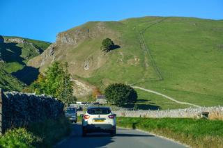
Castleton offers a route climbing Winnats Pass, a short but steep 2.1 km ascent starting right in Castleton. The climb gains 192 m in elevation with an average gradient of 9.2% and a maximum gradient of 15%. This route ends at 413 m above sea level. The terrain on Winnats Pass is mostly paved with 95%, and includes 5% gravel or unpaved sections. The route lies entirely within the United Kingdom and does not pass other towns or villages aside from Castleton itself.
More on terrain
Terrain
The route features a steep, continuous climb over 2.1 km with an average gradient of 9.2% and sections as steep as 15%. The highest point on the route is 413 m. The surface is predominantly paved but includes some gravel or unpaved sections.