
Cycling in Dibba
2 cycling routes from Dibba, Fujairah, United Arab Emirates, 44 to 59 km, 103 km mapped in all, with up to 1,699 m of climbing in a day. Mountainous riding (18 m of climbing per km on average), mostly road routes, 38% of the riding on main roads without a cycle lane. Best months to ride: Nov to Mar.
At a glance
- Routes
- 2
- Lengths
- 44–59 km
- Biggest day
- 1,699 m
- Terrain
- Mountainous
- Surface
- Mostly paved
- Bike
- Road bike
- Difficulty
- Easy to Hard
- Best months
- Nov to Mar
- Longest gap
- 48 km
- GPX
- Every route
Know before you go
Added up from the recorded routes and OpenStreetMap; nothing estimated.
- Surface
- Paved almost throughout.
- Roads
- 38% of the riding on main roads without a cycle lane.
- High point
- 1,468 m on Wadi Shees Climb from Dibba.
- Climbs
- 1 ascent of 500 m or more.
- No services
- 48 km on Wadi Shees Climb from Dibba.
Cycling guide to Dibba
Dibba, located in the Hajar Mountains of the United Arab Emirates, features a notable cycling route called the Wadi Shees climb. This 59.3 km loop passes through several places including Mayya, Al Harr, Tawiyean, Riyamah, Jerief, Ar Riwedah, Deira Al-Tamba, Al Marah, Wab Saqar, Dardur, and Dirat Az Zil'. The route stays within the UAE and involves significant climbing, making it a challenging ride for cyclists.
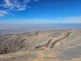
The Wadi Shees climb begins around 36.4 km into the loop, rises over 8.3 km with an elevation gain of 1,034 m, averaging a steep 12.5% gradient and reaching a maximum gradient of 18.9%, topping out at 1,468 m. Riders should note that the route is predominantly paved (97%) with a small section of gravel or unpaved surfaces (2%), and includes 6.1 km on main roads without cycle lanes. Services are sparse, with the longest stretch without any for 47.7 km.
More on best time to ride, terrain
Best time to ride
February offers temperatures around 17°C, suitable for riding the route.
Terrain
The terrain is mountainous with a significant climb starting at 36.4 km, lasting 8.3 km at an average gradient of 12.5% and a max gradient of 18.9%. The highest point on the route is 1,468 m. The route is mostly paved with some minor unpaved sections.