
Cycling in Port de Pollença
2 cycling routes from Port de Pollença, Mallorca, Spain, 49 to 131 km, 180 km mapped in all, with up to 720 m of climbing in a day. Rolling riding (8 m of climbing per km on average), mostly road routes, 20% of the riding on main roads without a cycle lane. Best months to ride: Apr to Jun.
At a glance
- Routes
- 2
- Lengths
- 49–131 km
- Biggest day
- 720 m
- Terrain
- Rolling
- Surface
- Mostly paved
- Bike
- Road bike
- Difficulty
- Moderate to Hard
- Named climbs
- 5
- Best months
- Apr to Jun
- Longest gap
- 17 km
- GPX
- Every route
Know before you go
Added up from the recorded routes and OpenStreetMap; nothing estimated.
- Surface
- Paved almost throughout — 6 km of gravel or unpaved road across the routes.
- Roads
- 20% of the riding on main roads without a cycle lane · 24 km on cycle paths or lanes.
- Climbs
- 5 named climbs.
- Bail-outs
- A railway station or ferry within reach on 2 routes.
Cycling guide to Port de Pollença
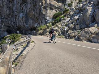
Port de Pollença in Mallorca, Spain, is a starting point for three main cycling routes. The Cap de Formentor lighthouse route is 49 km with 785 m elevation gain, featuring a 3.3 km climb averaging 5.8% gradient reaching 202 m. The mountain loop through Sóller and Fornalutx covers 97 km, gaining 1342 m with a 7.9 km climb averaging 5.5% to 534 m. The longest route is a 131 km loop to Palma with 707 m climbing and a gentler 3 km climb averaging 3%, topping at 123 m. These routes mainly have paved surfaces (92-96%) but include some gravel sections and vary in road types, with some main roads lacking cycle lanes.
More on best time to ride, terrain
Best time to ride
May with temperatures from 26°C to 30°C on the Cap de Formentor route, and around 27°C to 29°C on the longer routes.
Terrain
Terrain ranges from rolling to mountainous. The biggest climbs are 3.3 km at 5.8% average and 7.9 km at 5.5% average, with maximum gradients reaching up to 8.5%. Highest elevation reached is 872 m on the mountain loop route. The Palma loop is less hilly with a highest point at 183 m and more gentle climbs.